NAME: Mount Aconcagua
ELEVATION: 6,961 M (22,837 FT)
CONTINENT: South America
COUNTRY: Argentina, Mendoza Province
AREA: Andes Mountain Range
COORDINATES: 32°39’13”S 70°00’40”W
ROUTE: Normal Route, North West ridge
CHALLENGING: High Altitude
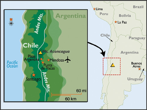
Aconcagua is the highest mountain outside of Asia and comes in as the second highest of the Seven Summits (right after Mother Everest). She reaches 6961 m (22,837 ft) and is located 112 km (70 mi) North West of the Mendoza city in Argentina and around 15 km (9.3 mi) from the international border with Chili. Mount Aconcagua is considered the highest non-technical mountain in the world. To pursue the Aconcagua a high level of fitness is required in order to keep up with the high altitude over a period that ranges between 18 and 20 days.
Weather
It is because of its weather that Mount Aconcagua is compared to the eight thousands of the Himalayas. The low humidity, low oxygen percentage and strong winds are some of the most outstanding characteristics of the weather of Mount Aconcagua. The main cause of storms and bad weather is mainly the wet winds originated in the Pacific Anticyclone. The winds go South and rise to the West clashing against the mountain range, cooling and thus releasing their humidity as snow on the high peaks of the Andes. Not only snow and wind-storms are common in Mount Aconcagua but also the feared electric storms, due to its geographical situation. Lightning bolts fall especially on the mountain peaks in the Northwest area and on the summit, making the stay and ascent difficult. Mt Aconcagua is often assailed by strong winds from the West (over 5500 meters above sea level), which added to the large size of the mountain, form the enormous and renowned “mushroom”. It is located in the upper part of mount Aconcagua and can be seen from Plaza de Mulas, creating a beautiful scenery and a terrible negative forecast of strong winds and precipitation. Approaching the summit in that moment would be deadly. When a storm approaches it is advisable to abandon the upper part of the mountain.
History of climbs
The first attempt to reach the summit of Aconcagua was made in 1883 by Paul Güssfeldt, a German mountaineer who bribed some local men to act as porters for him by claiming there was treasure on the mountain. With only poor equipment the team ascended and was able to reach 6560m in altitude during this primary attempt, but was forced to descend only 500m from the summit because of dangerously high winds. The first recorded successful ascent was made several years later in 1897 by a team led by the British man, Edward Fitzgerald. In 1944 the first ascension by a woman was achieved by Adriana Bance of France. Unfortunately, she died during her descent. These days there are about 3,500 climbers trying the summit each year.
Getting there
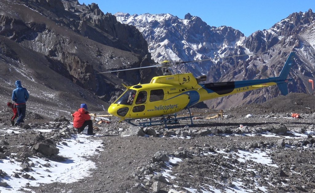
You might think of this as a crazy idea but it is well over-thought. When Jur finishes his expedition on Antarctica I told him to make his way to Mnt. Aconcagua as soon as possible and climb up to at least 3000 m. altitude. This in order to get the most benefit from acclimatization on Mnt Vinson. So when he is back in Punta Arenas he immediately flies on to Mendoza.
What to expect?
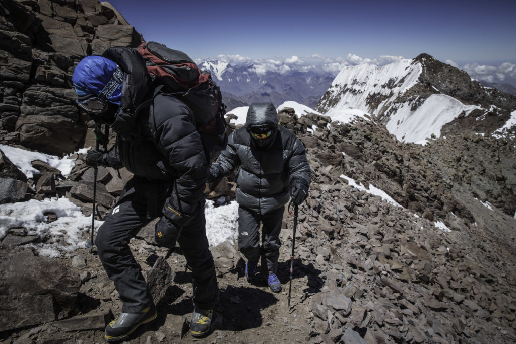
The ‘Normal Route’ is a non-technical – walk-up, following the Northwest Ridge. It is the altitude that poses the most problem. That and the sense that this is an easy climb. Every year people die because they underestimate the task at hand. Respect this mountain and we will fare better. Much of the hiking is on scree. On the Normal route there are no permanent snow fields, but crampons and ice axe may still be required in some sections. If we are fortunate the final 1,000 feet is covered with ice and snow and Jur can then crampon up this much more easily than when it is loose scree after a dry winter. Jur can expect to be exerting himself for about six hours per day and will be carrying a 15-20 kg pack. The altitude and weather combine to make this an adventure that tests even the toughest. In good conditions it is hard but not technically difficult. In bad conditions it is virtually unclimbable.
De normale route is een zeer veilige route. Dit komt omdat er een medische dienst is in de basiskampen Confluencia en Plaza de Mulas, waar het zorgniveau erg hoog is. Als er iets misgaat, kan er heel snel hulp ter plaatse zijn. Een groot voordeel van de route is dat de afdaling snel gaat en het slechts twee dagen duurt naar de uitgang van het Park. Een nadeel van de route is dat de hoge kampen erg worden blootgesteld aan windstormen.
Brief itinerary of the climb
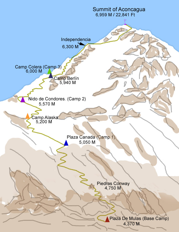
From Penitentes the team will drive to the entrance of the Park and trek to the Confluencia Camp. From here they will continue their ascent all the way to Plaza Francia (13200ft – 4000m) which is the base of the south face of Mnt. Aconcagua. A return descent to Confluencia will give them the chance to acclimatize. On day 5 the plan is to hike further up to Plaza de Mulas and lodging in the base camp (15008ft – 4370m). A resting day is scheduled to again, give the body the time needed to produce the so important red blood cells. Probably a short trek to Horcones glacier will be done to stay active and practice with crampons.
The next day they will leave Plaza de Mulas for a 6 hours acclimatization trekking to Mt. Bonete Summit (16702ft – 5091m) and return to Plaza de Mulas.
On the 8th day the team sets off for Camp 1 Canadá (16203ft – 4910m). Acclimatization and transportation of material to Camp 1 Canadá is hereby done and on the same day the team descents back to Base Camp for a resting and acclimatization day.
The next day they hike back up towards Camp 1 Canadá, set up the tents and rest.
Camp 2 Nido de Cóndores (17325ft – 5250m) is the next day’s mission followed by another day of rest and acclimatization.
On day 13 the group ascents further up to Camp 3 Berlín – Cólera (19470ft–5900m) to give the altitude stimulus to the body and transport meals and cooking elements. After lunch they return to Camp 2 Nido de Cóndores and rest because the day after they are going back up again to Camp 3.
After 15 days finally they can go for the big summit !! (22834ft – 6962m)
After a euphoric moment on the roof of South America and the very important Summit-pictures they descent towards Camp 3 the same day. The descent continuous during the following days and hopefully after 18 days Jur will set foot in Mendoza again.
Do it yourself!
Mnt. Aconcagua is a perfect mountain to test yourself at an altitude of up to 23,000 feet / 7000 meters, which is a great stepping stone for climbing the Himalaya mountains of 26,000 feet / 8200 meters. Since altitude is your main challenge here you want to climb on the mantra GO SLOW!! The itinerary above gives you a good idea of the climbing plan but needs to be interpreted as flexible due to weather inconveniences and your response to the altitude.
If you like extended information on for example the logistics around this expedition, feel free to leave a comment below or send me an email to; [email protected]

